School nearby Sanad Primary Girls School
Bahrain
School nearby Sanad Primary Girls School
Sanad Primary Girls School
Sanad, Bahrain
contacts phone
:
+973 1762 4341
Latitude:
26.1541493
, Longitude:
50.5788046
larger map & directions
read more
nearest School
24 m
Sanad Primary Girls School
Isa
School
read more
134 m
Sanad Primary Boys School
Isa
School
read more
154 m
Sanad Primary Boys School
Sanad
School
read more
400 m
UCMAS
Sanad
School
read more
404 m
Al Hekma International School
1962 Road No 4363, Sanad
School
read more
648 m
Alghars Almuthmer Centre
Road No 1545, Isa Town
School
read more
1.17 km
مدرسة عمار بن ياسر الابتدائية للبنين
Road No 1525, Isa Town
School
read more
1.205 km
Friendship for the Blind
Isa
School
read more
1.268 km
The New Indian School
Isa Town
School
read more
1.288 km
Fairytopia Club
Riffa
School
read more
1.712 km
Shaikhan Al Farsi Center for Total Communication
Building 189 Avenue 37 Block 933 East riffa
School
read more
1.724 km
Alandalus School
Riffa
School
read more
1.773 km
Al Andalus Primary Girls School
Isa
School
read more
1.928 km
Malik bin anas primary boys school
Riffa
School
read more
1.933 km
مدرسة الإمام مالك بن انس الابتدائية للبنين
Riffa
School
read more
1.953 km
Malik Boys
Riffa
School
read more
1.977 km
Al Emam Malik Bin Anas Primary Boys School
Isa
School
read more
2.186 km
Othman Bin Affan Primary And Intermediate Boys School
Isa Town
School
read more
2.189 km
Al noor Campus C
near kuwait finance house
School
read more
2.259 km
Al Emmam Al Tabari Primary Boys School
Road No 1301, Isa
School
read more
2.776 km
Al Noor International School
Sitra
School
read more
2.888 km
الحوزة الجعفرية للدراسات الإسلامية
Nuwaidrat
School
read more
2.912 km
Oqaba Bin Nafea Primary Boys School
Building 504 Road 1311, Riffa
School
read more
2.962 km
Nuwadirat Primary Girls School
Road No 4458, Nuwaidrat
School
read more
3.067 km
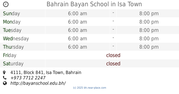
Bahrain Bayan School
4111, Block 841, Isa Town
School
read more
📑
all categories
Accounting
Administrative area level 1
Airport
Amusement park
Aquarium
Art gallery
Atm
Bakery
Bank
Bar
Beauty salon
Bicycle store
Book store
Bowling alley
Bus station
Cafe
Campground
Car dealer
Car rental
Car repair
Car wash
Cemetery
Church
City hall
Clothing store
Convenience store
Country
Courthouse
Dentist
Department store
Doctor
Electrician
Electronics store
Embassy
Establishment
Finance
Fire station
Florist
Food
Funeral home
Furniture store
Gas station
General contractor
Grocery or supermarket
Gym
Hair care
Hardware store
Health
Hindu Temple
Home goods store
Hospital
Insurance agency
Jewelry store
Laundry
Lawyer
Library
Liquor store
Local government office
Locality
Locksmith
Lodging
Meal delivery
Meal takeaway
Mosque
Movie rental
Movie theater
Moving company
Museum
Natural feature
Neighborhood
Night club
Painter
Park
Parking
Pet store
Pharmacy
Physiotherapist
Place of worship
Plumber
Point of interest
Police
Post office
Premise
Real estate agency
Restaurant
Route
School
Shoe store
Shopping mall
Spa
Stadium
Storage
Store
Subpremise
Subway station
Supermarket
Synagogue
Taxi stand
Travel agency
University
Veterinary care
sublocality level 1
↑