School nearby Nuwadirat Primary Girls School
Bahrain
School nearby Nuwadirat Primary Girls School
Nuwadirat Primary Girls School
Road No 4458, 644, Nuwaidrat, BH Bahrain
contacts phone
:
+973 1770 0295
website:
www.moe.gov.bh
Latitude:
26.1359361
, Longitude:
50.6004608
larger map & directions
read more
nearest School
292 m
Umm Alqura Primary Girls School
Isa
School
read more
329 m
الحوزة الجعفرية للدراسات الإسلامية
Nuwaidrat
School
read more
1.277 km
Al Emam Ali Bin Abi Talib Primary and Intermediate School
Ma'ameer
School
read more
1.338 km
Imam Ameer Almoamneen Hawza
Road No 3405, Ma'ameer
School
read more
2.342 km
The Indian School
Road No 3933, Isa Town
School
read more
2.384 km
معهد الفاتح سابقا
Riffa
School
read more
2.731 km
East Riffa Intermediate Girls School
Alhajiyat
School
read more
2.751 km
East Riffa School for Girls. Riffa Alcherqa.mmlkh Bahrain
Highway 96, Riffa
School
read more
2.809 km
Sanad Primary Boys School
Sanad
School
read more
2.828 km
مدرسة الوحدة الثانوية للبنين
Building 307, Road No 2513, Riffa
School
read more
2.831 km
East Riffa Secondary Boys School
Riffa
School
read more
2.844 km
Sanad Primary Boys School
Isa
School
read more
2.881 km
UCMAS
Sanad
School
read more
2.905 km
Al Andalus Primary Girls School
Isa
School
read more
2.918 km
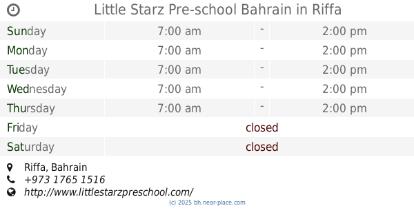
Little Starz Pre-school Bahrain
Riffa
School
read more
2.927 km
Alandalus School
Riffa
School
read more
2.94 km
Salah Al-deen Primary Boys School
Riffa
School
read more
2.949 km
Salah Al-Deen Primary Boys school
Isa
School
read more
2.962 km
Sanad Primary Girls School
Sanad
School
read more
2.968 km
Sanad Primary Girls School
Isa
School
read more
3.019 km
Fatima Bint Al Khatab Primary Girls School
Isa
School
read more
3.042 km
Al Hekma International School
1962 Road No 4363, Sanad
School
read more
3.431 km
Alghars Almuthmer Centre
Road No 1545, Isa Town
School
read more
3.525 km
Al Noor International School
Sitra
School
read more
4.053 km
Oqaba Bin Nafea Primary Boys School
Building 504 Road 1311, Riffa
School
read more
📑
all categories
Accounting
Administrative area level 1
Airport
Amusement park
Aquarium
Art gallery
Atm
Bakery
Bank
Bar
Beauty salon
Bicycle store
Book store
Bowling alley
Bus station
Cafe
Campground
Car dealer
Car rental
Car repair
Car wash
Cemetery
Church
City hall
Clothing store
Convenience store
Country
Courthouse
Dentist
Department store
Doctor
Electrician
Electronics store
Embassy
Establishment
Finance
Fire station
Florist
Food
Funeral home
Furniture store
Gas station
General contractor
Grocery or supermarket
Gym
Hair care
Hardware store
Health
Hindu Temple
Home goods store
Hospital
Insurance agency
Jewelry store
Laundry
Lawyer
Library
Liquor store
Local government office
Locality
Locksmith
Lodging
Meal delivery
Meal takeaway
Mosque
Movie rental
Movie theater
Moving company
Museum
Natural feature
Neighborhood
Night club
Painter
Park
Parking
Pet store
Pharmacy
Physiotherapist
Place of worship
Plumber
Point of interest
Police
Post office
Premise
Real estate agency
Restaurant
Route
School
Shoe store
Shopping mall
Spa
Stadium
Storage
Store
Subpremise
Subway station
Supermarket
Synagogue
Taxi stand
Travel agency
University
Veterinary care
sublocality level 1
↑