School nearby St Christopher's, Primary School
Bahrain
School nearby St Christopher's, Primary School
St Christopher's, Primary School
Gate 790, Road 1322, Block 513, Maqabah, Bahrain
contacts phone
:
+973 1759 8600
website:
www.st-chris.net
Latitude:
26.205042
, Longitude:
50.499
larger map & directions
read more
nearest School
133 m
Colts Cricket Academy
St. Christopher Primary school, Saar
School
read more
167 m
House of stories
Maqabah
School
read more
1.098 km
Diaa Kindergarten
Villa 100 Road 7703 block 477 Shakhoora،، Shakhoora
School
read more
1.166 km
Lucky Kids Pre-School
Shakhurah
School
read more
1.169 km
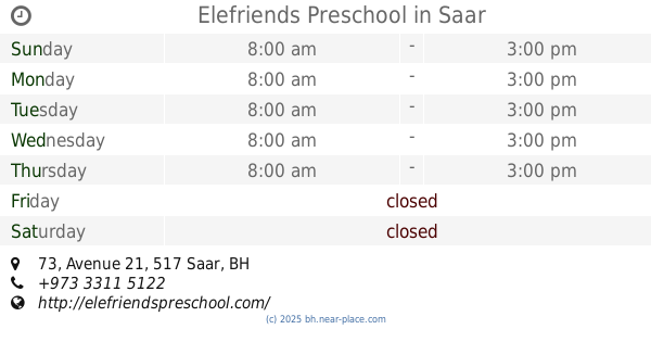
Elefriends Preschool
73 Avenue 21, Saar
School
read more
1.182 km
Norwegian Wood Nursery
Saar
School
read more
1.205 km
Al Wisam School
Abu Saiba
School
read more
1.256 km
Shakurah Riding School
Shakhurah
School
read more
1.317 km
Al Mahd School
Saar
School
read more
1.318 km
Meditation center
Maqabah
School
read more
1.427 km
Abu Saiba Primary Boys School
66 Avenue 73, Abu Saiba
School
read more
1.581 km
جمعية ملتقى الشباب البحريني
Abu Saiba
School
read more
1.609 km
مركز الرشاد للتوحد
Road No 1545, Saar
School
read more
1.645 km
Hanvang Chinese training W.L.L
Unnamed Road, Abu Saiba
School
read more
1.66 km
Let's Speak French
Rd, B
School
read more
1.676 km
Fatima Bint Asad Primary Girls School
Abu Saiba
School
read more
1.691 km
Future Geniuses
Road No 2127, Saar
School
read more
1.705 km
Fatema Bin Asad Girl School
Al Hajar
School
read more
1.795 km
Bint Alhuda
Road No 2333, Saar
School
read more
1.855 km
Study Time
Saar
School
read more
2.043 km
Al Fajer Private School
Road 85, Building 1788, Block 520, Barbar
School
read more
2.062 km
Japanese School
Road No 3363, Saar
School
read more
2.087 km
Almuheet Institute
Al Maqsha
School
read more
2.114 km
Japanese School
Saar
School
read more
2.34 km
Altafawk Center
Al Maqsha، Bahrain
School
read more
📑
all categories
Accounting
Administrative area level 1
Airport
Amusement park
Aquarium
Art gallery
Atm
Bakery
Bank
Bar
Beauty salon
Bicycle store
Book store
Bowling alley
Bus station
Cafe
Campground
Car dealer
Car rental
Car repair
Car wash
Cemetery
Church
City hall
Clothing store
Convenience store
Country
Courthouse
Dentist
Department store
Doctor
Electrician
Electronics store
Embassy
Establishment
Finance
Fire station
Florist
Food
Funeral home
Furniture store
Gas station
General contractor
Grocery or supermarket
Gym
Hair care
Hardware store
Health
Hindu Temple
Home goods store
Hospital
Insurance agency
Jewelry store
Laundry
Lawyer
Library
Liquor store
Local government office
Locality
Locksmith
Lodging
Meal delivery
Meal takeaway
Mosque
Movie rental
Movie theater
Moving company
Museum
Natural feature
Neighborhood
Night club
Painter
Park
Parking
Pet store
Pharmacy
Physiotherapist
Place of worship
Plumber
Point of interest
Police
Post office
Premise
Real estate agency
Restaurant
Route
School
Shoe store
Shopping mall
Spa
Stadium
Storage
Store
Subpremise
Subway station
Supermarket
Synagogue
Taxi stand
Travel agency
University
Veterinary care
sublocality level 1
↑