School nearby Riffa Middle School
Bahrain
School nearby Riffa Middle School
Riffa Middle School
Ar-Rifa, Bahrajn
contacts phone
:
+973
Latitude:
26.1331837
, Longitude:
50.5625562
larger map & directions
read more
nearest School
132 m
Riffa Intermediate Boys School
ASRAAR.GENNY.ABAYAT.CO.W.L.L
School
read more
179 m
مدرسة الرفاع الاعدادية للبنين
Riffa
School
read more
226 m
Greenline Stationery
Deebal Avenue, Riffa
School
read more
283 m
مدرسة الفلاح الخاصة
Road No 1920, Riffa
School
read more
288 m
Oqaba Bin Nafea Primary Boys School
Building 504 Road 1311, Riffa
School
read more
328 m
Al Huda Kindergarten
Block 913, Riffa
School
read more
342 m
Al Maariffa Secondary Girls School
Isa Town
School
read more
406 m
Al-Mustaqbal Primary Girls School
Riffa
School
read more
413 m
Mustqbal Elementary School for Girls
Building 323 Road 1307, Riffa
School
read more
563 m
Talent International & The Infant School
Road No 2506, Riffa
School
read more
650 m
Al noor Campus C
near kuwait finance house
School
read more
682 m
Creative Nursery
Riffa
School
read more
693 m
Clever Kid Pre-School
Riffa
School
read more
847 m
Melody Town Learning Center
Flat No 23 Building 45 Road 14, Riffa
School
read more
878 m
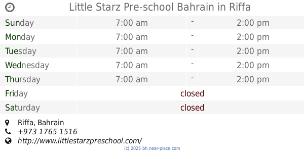
Little Starz Pre-school Bahrain
Riffa
School
read more
879 m
Fatima Bint Al Khatab Primary Girls School
Isa
School
read more
958 m
مركز الانشطة الثقافية والفنية في الرفاع
Alriffa Avenue, Riffa
School
read more
974 m
Happy Childhood Kindergarten روضة الطفوله السعيده
Road No 1503
School
read more
1.017 km
مدرسة الإمام مالك بن انس الابتدائية للبنين
Riffa
School
read more
1.023 km
Malik bin anas primary boys school
Riffa
School
read more
1.031 km
AlNour Mosque Rifaa
Riffa
School
read more
1.092 km
Salah Al-Deen Primary Boys school
Isa
School
read more
1.095 km
Salah Al-deen Primary Boys School
Riffa
School
read more
1.151 km
Al Andalus Primary Girls School
Isa
School
read more
1.178 km
Alandalus School
Riffa
School
read more
📑
all categories
Accounting
Administrative area level 1
Airport
Amusement park
Aquarium
Art gallery
Atm
Bakery
Bank
Bar
Beauty salon
Bicycle store
Book store
Bowling alley
Bus station
Cafe
Campground
Car dealer
Car rental
Car repair
Car wash
Cemetery
Church
City hall
Clothing store
Convenience store
Country
Courthouse
Dentist
Department store
Doctor
Electrician
Electronics store
Embassy
Establishment
Finance
Fire station
Florist
Food
Funeral home
Furniture store
Gas station
General contractor
Grocery or supermarket
Gym
Hair care
Hardware store
Health
Hindu Temple
Home goods store
Hospital
Insurance agency
Jewelry store
Laundry
Lawyer
Library
Liquor store
Local government office
Locality
Locksmith
Lodging
Meal delivery
Meal takeaway
Mosque
Movie rental
Movie theater
Moving company
Museum
Natural feature
Neighborhood
Night club
Painter
Park
Parking
Pet store
Pharmacy
Physiotherapist
Place of worship
Plumber
Point of interest
Police
Post office
Premise
Real estate agency
Restaurant
Route
School
Shoe store
Shopping mall
Spa
Stadium
Storage
Store
Subpremise
Subway station
Supermarket
Synagogue
Taxi stand
Travel agency
University
Veterinary care
sublocality level 1
↑