School nearby Kindergarten Sinbad
Bahrain
School nearby Kindergarten Sinbad
Kindergarten Sinbad
Highway 71, Buri, BH Bahrajn
contacts phone
:
+973 1764 1881
Latitude:
26.1495718
, Longitude:
50.5060253
larger map & directions
read more
nearest School
800 m
Buri Primary Girls School
Buri
School
read more
859 m
Buri Primary Boys School
Buri
School
read more
860 m
Buri Primary Boys School
Road No 5602, Buri
School
read more
1.404 km
مشروع هيا نتعلم الصلاة - مسجد الإمام الحسن~ع
Road No 3439, A'ali
School
read more
1.469 km
المركز التعليمي الثقافي
Road No 3870, A'ali
School
read more
1.627 km
Aldheya Primary Boys School مدرسة الضياء الابتدائية للبنين
A'ali
School
read more
1.725 km
Math Center
4861, Highway 71, A'ali
School
read more
1.857 km
A'Ali Intermediate Girls School
A'ali
School
read more
2.059 km
Aali Primary Girls School
206 Road No 3608, A'ali
School
read more
2.104 km
Philippine School Bahrain
PO BOX 10417 Building 989 Road: 3222 Block: 732, Road No 3222, A'ali
School
read more
2.177 km
Bangladesh school bahrain(Proposed) (প্রস্তাবিত)
Road no 3222, Block no 734, A'ali, Kingdom of Bahrain
School
read more
2.286 km
Al Falah Private Schools girls Branch A'ali
A'ali
School
read more
2.303 km
Falah privet school
Road No 3222, A'ali
School
read more
2.311 km
Al Falah Kindergarten
A'ali
School
read more
2.322 km
AlFalah Private Schools Boys Branch
A'ali
School
read more
2.455 km
Ma'aly Gate School
Hoarat A'ali
School
read more
2.478 km
Little Learners Daycare
A'ali
School
read more
2.617 km
Aali boys primary school مدرسة عالي الابتدائية للبنين
A'ali
School
read more
2.649 km
A'ali Primary Boys School
A'ali
School
read more
2.789 km
Driving school
Hoarat A'ali
School
read more
2.93 km
My Car Driving School
Hoarat A'ali
School
read more
4.499 km
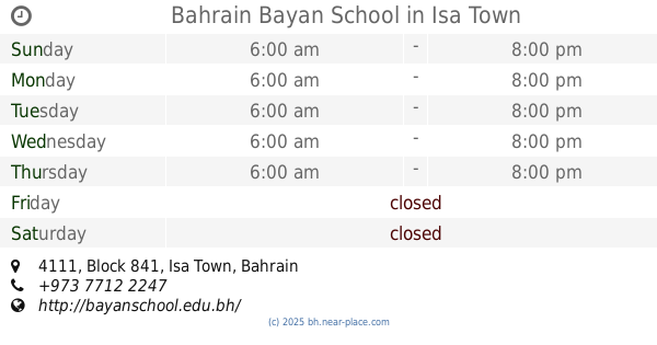
Bahrain Bayan School
4111, Block 841, Isa Town
School
read more
4.92 km
Reach Nursery
Isa Town
School
read more
4.972 km
Umaima Bint Al Nomman Secondary Girls School
Isa Town
School
read more
5.5 km
Tubli Girls Primary School
Tubli
School
read more
📑
all categories
Accounting
Administrative area level 1
Airport
Amusement park
Aquarium
Art gallery
Atm
Bakery
Bank
Bar
Beauty salon
Bicycle store
Book store
Bowling alley
Bus station
Cafe
Campground
Car dealer
Car rental
Car repair
Car wash
Cemetery
Church
City hall
Clothing store
Convenience store
Country
Courthouse
Dentist
Department store
Doctor
Electrician
Electronics store
Embassy
Establishment
Finance
Fire station
Florist
Food
Funeral home
Furniture store
Gas station
General contractor
Grocery or supermarket
Gym
Hair care
Hardware store
Health
Hindu Temple
Home goods store
Hospital
Insurance agency
Jewelry store
Laundry
Lawyer
Library
Liquor store
Local government office
Locality
Locksmith
Lodging
Meal delivery
Meal takeaway
Mosque
Movie rental
Movie theater
Moving company
Museum
Natural feature
Neighborhood
Night club
Painter
Park
Parking
Pet store
Pharmacy
Physiotherapist
Place of worship
Plumber
Point of interest
Police
Post office
Premise
Real estate agency
Restaurant
Route
School
Shoe store
Shopping mall
Spa
Stadium
Storage
Store
Subpremise
Subway station
Supermarket
Synagogue
Taxi stand
Travel agency
University
Veterinary care
sublocality level 1
↑