School nearby Huneniya Primary Girls School
Bahrain
School nearby Huneniya Primary Girls School
Huneniya Primary Girls School
Alhunayniyah, Riffa, Bahrain
contacts phone
:
+973
Latitude:
26.1188413
, Longitude:
50.5634011
larger map & directions
read more
nearest School
23 m
Nosaiba Bint Kaab Primary Girls School
Ar-Rifaa
School
read more
110 m
East Rifa Primary Boys School
Ar-Rifaa
School
read more
118 m
East Riffa Primary Boys School
Riffa
School
read more
290 m
Honenia Secondary Boys school
Riffa
School
read more
295 m
Al Fateh school
Riffa
School
read more
296 m
Ibn Rushed Intermediate Boys School
Riffa
School
read more
328 m
Ibn Rushed Primary Intermediate Boys School
Ar-Rifaa
School
read more
338 m
Al Fateh Secondary School for Boys
Riffa
School
read more
353 m
مدرسة ابن رشد الرفاع
الحنينية، الرفاع،
School
read more
472 m
مدرسة الرفاع الشرقي
Sh Ali Bin Khalifa Avenue, Riffa
School
read more
517 m
Future Nursery
Road No 151, Riffa
School
read more
688 m
Madarek Books & Stationery Store
Road No 519, Riffa
School
read more
732 m
مركز الانشطة الثقافية والفنية في الرفاع
Alriffa Avenue, Riffa
School
read more
749 m
AlNour Mosque Rifaa
Riffa
School
read more
1.017 km
Clever Kid Pre-School
Riffa
School
read more
1.335 km
Talent International & The Infant School
Road No 2506, Riffa
School
read more
1.38 km
Al Huda Kindergarten
Block 913, Riffa
School
read more
1.386 km
Salah Al-deen Primary Boys School
Riffa
School
read more
1.394 km
مدرسة الوحدة الثانوية للبنين
Building 307, Road No 2513, Riffa
School
read more
1.743 km
Oqaba Bin Nafea Primary Boys School
Building 504 Road 1311, Riffa
School
read more
1.832 km
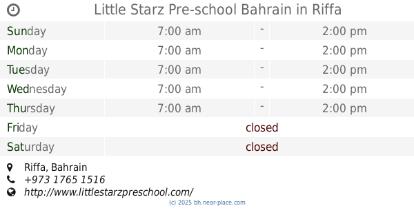
Little Starz Pre-school Bahrain
Riffa
School
read more
1.888 km
Al Maariffa Secondary Girls School
Isa Town
School
read more
1.891 km
Mustqbal Elementary School for Girls
Building 323 Road 1307, Riffa
School
read more
1.95 km
مركز الرفاع لمصادر المعرفة
Riffa
School
read more
2.017 km
Al Khaleej Arabi Primary Girls School
Isa
School
read more
📑
all categories
Accounting
Administrative area level 1
Airport
Amusement park
Aquarium
Art gallery
Atm
Bakery
Bank
Bar
Beauty salon
Bicycle store
Book store
Bowling alley
Bus station
Cafe
Campground
Car dealer
Car rental
Car repair
Car wash
Cemetery
Church
City hall
Clothing store
Convenience store
Country
Courthouse
Dentist
Department store
Doctor
Electrician
Electronics store
Embassy
Establishment
Finance
Fire station
Florist
Food
Funeral home
Furniture store
Gas station
General contractor
Grocery or supermarket
Gym
Hair care
Hardware store
Health
Hindu Temple
Home goods store
Hospital
Insurance agency
Jewelry store
Laundry
Lawyer
Library
Liquor store
Local government office
Locality
Locksmith
Lodging
Meal delivery
Meal takeaway
Mosque
Movie rental
Movie theater
Moving company
Museum
Natural feature
Neighborhood
Night club
Painter
Park
Parking
Pet store
Pharmacy
Physiotherapist
Place of worship
Plumber
Point of interest
Police
Post office
Premise
Real estate agency
Restaurant
Route
School
Shoe store
Shopping mall
Spa
Stadium
Storage
Store
Subpremise
Subway station
Supermarket
Synagogue
Taxi stand
Travel agency
University
Veterinary care
sublocality level 1
↑