Cafe nearby Central Cafe
Bahrain
Cafe nearby Central Cafe
Central Cafe
Manama, Bahrain
contacts phone
:
+973
Latitude:
26.2278338
, Longitude:
50.5798745
larger map & directions
read more
nearest Cafe
176 m
King karak ghudaibia
Road No 724, Manama
Cafe
read more
221 m
Awal Square Cafeteria
Al Zahara Avenue, Manama
Cafe
read more
229 m
Al Manshia Cafe Shisha Center
Manama
Cafe
read more
257 m
Konkan Singer's Club
Shaikh Isa Avenue, Manama
Cafe
read more
337 m
PAPAS Icecream
شارع المتنبي،, Manama
Cafe
read more
518 m
റെസ്റ്റോറന്റ്
Road No 715, Manama
Cafe
read more
569 m
Cooki Chai
Road No 213, Manama
Cafe
read more
652 m
Al Mawardi Cafe - قهوة المواردي
Manama
Cafe
read more
798 m
Nine Ball Cafe
Palace Ave, Al Manam, Manama
Cafe
read more
987 m
Al Jamaheer Coffee
Zubara Avenue, Block 318, Manama
Cafe
read more
1.158 km
Veranda Restaurant and Café
7 Delmun Avenue, Manama
Cafe
Point of interest
Food
Establishment
read more
1.158 km
Veranda Restaurant and Café
372 Block 327, Shaikh Isa Avenue, Manama
Cafe
read more
1.158 km
Veranda
2702, Manama
Cafe
read more
1.188 km
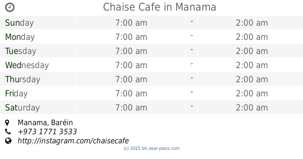
Chaise Cafe
Manama
Cafe
read more
1.207 km
STARBUCKS COFFEE
Rd No 2603, Manama, Bahrain, Manama
Cafe
read more
1.226 km
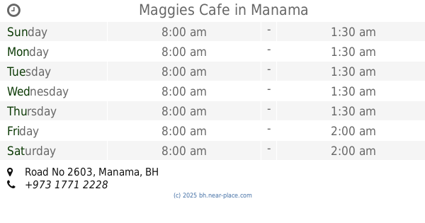
Maggies Cafe
Road No 2603, Manama
Cafe
read more
1.239 km
Adliya Building 42 Caffee
Road No 2614, Manama
Cafe
read more
1.285 km
Don Vito Cafe
Manama
Cafe
read more
1.325 km
Al Bindaira Cafe
Building 171 Road 2608 Block 326, Road No 2608, Manama
Cafe
read more
1.329 km
Coffee Hut كوخ القهوة
Road No 2608, Manama
Cafe
read more
1.335 km
Arizona Cafe
شارع اسامة بن زيد بالعدلية, Manama
Cafe
read more
1.337 km
Bindera cafe
Road No 2608, Manama
Cafe
read more
1.339 km
Extrovert Cafe
Road No 2608, Manama
Cafe
Point of interest
Food
Establishment
read more
1.355 km
Awtar Beirut Restaurant
Road No 2601, Manama
Cafe
read more
1.601 km
AL SITEEN CAFE
SHOP 24 BUILDING 752, Manama
Cafe
read more
📑
all categories
Accounting
Administrative area level 1
Airport
Amusement park
Aquarium
Art gallery
Atm
Bakery
Bank
Bar
Beauty salon
Bicycle store
Book store
Bowling alley
Bus station
Cafe
Campground
Car dealer
Car rental
Car repair
Car wash
Cemetery
Church
City hall
Clothing store
Convenience store
Country
Courthouse
Dentist
Department store
Doctor
Electrician
Electronics store
Embassy
Establishment
Finance
Fire station
Florist
Food
Funeral home
Furniture store
Gas station
General contractor
Grocery or supermarket
Gym
Hair care
Hardware store
Health
Hindu Temple
Home goods store
Hospital
Insurance agency
Jewelry store
Laundry
Lawyer
Library
Liquor store
Local government office
Locality
Locksmith
Lodging
Meal delivery
Meal takeaway
Mosque
Movie rental
Movie theater
Moving company
Museum
Natural feature
Neighborhood
Night club
Painter
Park
Parking
Pet store
Pharmacy
Physiotherapist
Place of worship
Plumber
Point of interest
Police
Post office
Premise
Real estate agency
Restaurant
Route
School
Shoe store
Shopping mall
Spa
Stadium
Storage
Store
Subpremise
Subway station
Supermarket
Synagogue
Taxi stand
Travel agency
University
Veterinary care
sublocality level 1
↑