Bakery nearby Eastern Bakery
Bahrain
Bakery nearby Eastern Bakery
Eastern Bakery
824, Road No 425, Sanabis, BH Bahrain
contacts phone
:
+973 1721 1325
Latitude:
26.2231431
, Longitude:
50.5445834
larger map & directions
read more
nearest Bakery
618 m
Sanabis Housing Bakery
Sanabis
Bakery
read more
625 m
خباز الصاغة
Jidhafs
Bakery
read more
880 m
Kuboos Shop
Aldaih Roundabout, Daih
Bakery
read more
927 m
Alfalah Bakery
Jidhafs
Bakery
read more
942 m
Middle East Bakery
5425 354, Road No 2833, Al Burhama
Bakery
read more
1.058 km
مخبز نور البيان
جدحفص،
Bakery
read more
1.132 km
Almanar Bakeries and Pastries
Budaiya Highway, Jidhafs
Bakery
read more
1.141 km
معجنات راهي
Budaiya Highway, Jidhafs
Bakery
read more
1.262 km
Al Ressala Bakery
26°12'43.2"N 50°32'33., Avenue 7, Tashan
Bakery
read more
1.264 km
Cake Boutique
Building 2050, Road No 2825, Seef
Bakery
read more
1.426 km
Krispy Kreme Doughnuts
Manama
Bakery
read more
1.559 km
BreadTalk
Block 346, Manama
Bakery
read more
1.642 km
Mesk Holdings
Building 2317, Road 2830, Seef District 428, Seef
Bakery
read more
1.66 km
خبز محلة وجبن
Jeblat Hebshi
Bakery
read more
1.721 km
خباز حميد علي
Karbabad
Bakery
read more
1.934 km
Donut Inn
Al Musalla
Bakery
read more
2.032 km
Seven Doors Bakery خباز القفول
Road No1225, Manama
Bakery
read more
2.039 km
مخبز سبعة ابواب Goful Bakery And Cold Store
Road No 1220, Manama
Bakery
read more
2.205 km
Bakery خباز
Bilad Al Qadeem
Bakery
read more
2.594 km
REAL TASTE BAKERY, SWEETS & NUTS
Salmaniya Avenue
Bakery
read more
2.668 km
Al Batra Bakery
Bilad Al Qadeem
Bakery
read more
2.669 km
Al Dasmah Bakery
Manama
Bakery
read more
2.905 km
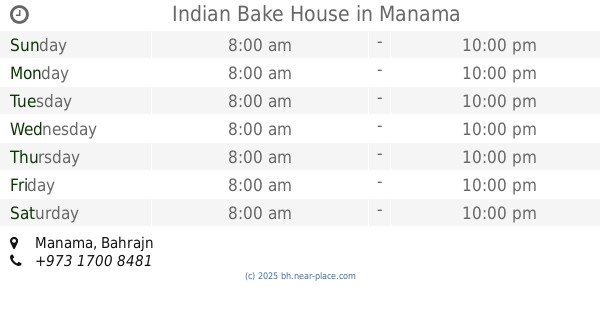
Indian Bake House
Manama
Bakery
read more
2.938 km
Decorating Memories
Shop 448, Building 450,, شارع 13, توبلي
Cafe
Bakery
Store
Point of interest
Food
Establishment
read more
4.964 km
حلويات سعد الدين
شارع الزباره مجمع 318 الحوره دكان 18، المنامه، البحرين
Bakery
read more
📑
all categories
Accounting
Administrative area level 1
Airport
Amusement park
Aquarium
Art gallery
Atm
Bakery
Bank
Bar
Beauty salon
Bicycle store
Book store
Bowling alley
Bus station
Cafe
Campground
Car dealer
Car rental
Car repair
Car wash
Cemetery
Church
City hall
Clothing store
Convenience store
Country
Courthouse
Dentist
Department store
Doctor
Electrician
Electronics store
Embassy
Establishment
Finance
Fire station
Florist
Food
Funeral home
Furniture store
Gas station
General contractor
Grocery or supermarket
Gym
Hair care
Hardware store
Health
Hindu Temple
Home goods store
Hospital
Insurance agency
Jewelry store
Laundry
Lawyer
Library
Liquor store
Local government office
Locality
Locksmith
Lodging
Meal delivery
Meal takeaway
Mosque
Movie rental
Movie theater
Moving company
Museum
Natural feature
Neighborhood
Night club
Painter
Park
Parking
Pet store
Pharmacy
Physiotherapist
Place of worship
Plumber
Point of interest
Police
Post office
Premise
Real estate agency
Restaurant
Route
School
Shoe store
Shopping mall
Spa
Stadium
Storage
Store
Subpremise
Subway station
Supermarket
Synagogue
Taxi stand
Travel agency
University
Veterinary care
sublocality level 1
↑